| Data and Documentation | Chronology and News | Program Status | Publications | Related Data and Resources | Contact Points |
ICOADS Web information page (Wednesday, 21-Nov-2007 17:56:37 UTC):
UK Royal Navy (RN) WW II Logs and the Marine Data Bank (MDB)
1. Introduction
This webpage (plus Addendum) provides a collection of information about UK Royal Navy (RN) logbooks during the World War II period. This includes results that shed some light on the extent to which meteorological data from the logbooks were previously digitized into the UK Marine Data Bank (MDB)-and thus are already available in ICOADS. Two separate, and partially overlapping, logbook collections are available:
- Ship's Logs: archived at The UK National Archives (TNA). In Rhodes (1994) (hereafter R94), these are referred to as "Deck Logs." Under a joint UK/US project, a selection of approximately 260K pages from Ship's Log's for 1938-47 was imaged (in b&w) by early 2006, with digitization of the meteorological data by the NOAA Climate Database Modernization Program (CDMP) planned to begin in the next several months. Monthly Logs from submarines are also included in this project. Significant numbers of the imaged (daily observational) pages were recorded in port, but at least some meteorological observations generally were still made at anchor (e.g., sea level pressure, as shown in Figure 1a; Figure 1b illustrates the format from a submarine Log). Little or no instrumental metadata appear to be available from the Ship's Logs, whereas they contain considerable ship operational and personnel details, in addition to the meteorological observations. However, the cover and following page (Figures 1c-1d) contain some overall ship metadata, such as tonnage and ship type ("Navy List Description"). R94 indicates that the Ship's Logs were "made by professional mariners but with ships instrumentation."
- Meteorological (Met) Logs: archived at the UK Met Office. These higher-quality observations, apparently limited to "large warships or the senior ship of a squadron" were taken by "qualified Meteorological Officers...from precision instruments," who "did not normally take observations during the hours of darkness and therefore most logs record observations only three times a day usually 0800, 1200 and 1800. However some logs do contain considerably more observations than this normal standard..." (from R94). Each Met Log includes a standard set of instructions to the observer, and the Logs include space for instrumental metadata plus for some more specialized observation types (discussed below).
Possibly with the limited space on the card form as one factor, none of the instrumental metadata was keyed from the Met Logs into the MDB (nor was any ship name or other ID information keyed, as discussed in sec. 2). Based on a limited inspection in 2005 (i.e., of the six sample Met Logs described in sec. 3), Philip Brohan provided the following notes on the metadata and ancillary data types:
"The barometer height and location are usually given, sometimes the thermometer height and location also-in a couple of cases details on the instrument source and calibration is given. There is also a set of standard instructions to observers inside each logbook. But the amount and quality varied dramatically even through this sample of 6 logs.Sec. 2 of this webpage describes the coverage during 1930-49 of the MDB data already in ICOADS, including the selected data digitized (possibly around the 1960s) from Met Logs into deck 204. Sec. 3 provides the results of comparisons between Ship's Logs for six sample voyages, and MDB deck 204 data that were reported at the same approximate locations.
The met logs contain a wealth of data-as well as the routine obs there are barograph charts and synoptic plots pasted in, wind records from balloon launches and occasional tephigrams from aeroplane launches. There are daily comments on the weather, and annotations on the barograph charts.
I didn't copy the logs-the pasted in inserts, size of the log-books, and restricted photocopying facilities in the Archive mean that this would have taken a very long time for a poor result."
2. Temporal and Spatial Distribution of MDB Decks for 1930-49
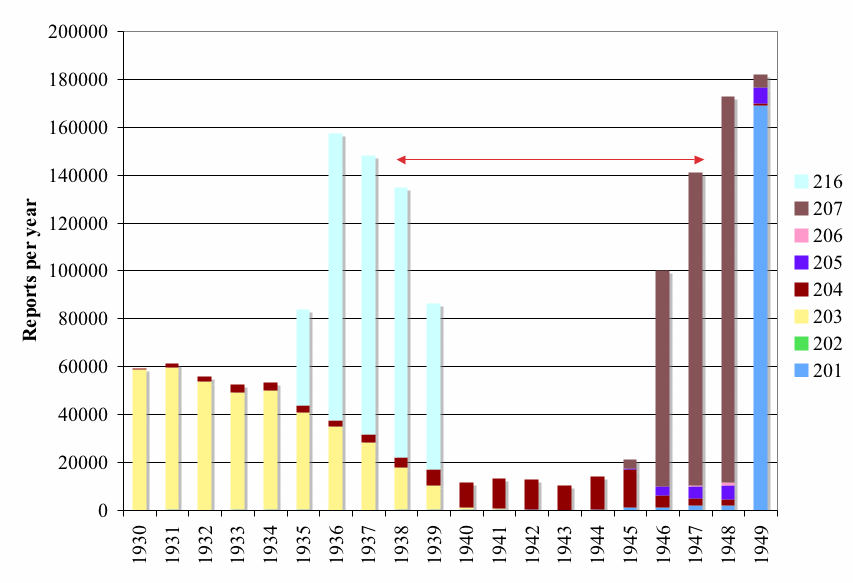
This section illustrates the spatial (Figures 2a-2t) and temporal (Figure 3, below) distribution of the MDB data (provided during 1998-2000 by Jim Arnott, UK Met Office, in LMR format) during the period 1930-49. These data were blended into the current ICOADS Release (originally as part of Release 1c, covering 1784-1949). However, these plots show the data coverage prior to blending, and thus before any duplicates have been removed. Table 1 lists the applicable decks.
Figures 2a-2t highlight deck 204, which consists of data keyed from the Met Logs. UK Met Office (c. 1960s) describes series 4 (deck 204) as:
- "Data from Admiralty logs for years 1930-48. Coded in 1930 code."
- "Data for years 1945-48. Coded in 1930 code."
- "Data for years 1949-54 including data from Admiralty logs. Coded in 1949 code."
UK Met Office (c. 1960s) also provides the following information about Folio number (which, if available, might serve as a useful identification field in the absence of ship ID): "The number of the log in which the observations were recorded. For Series 5 these columns were not punched. The name of the ship making the observation was written on the back of the card. For data from Admiralty logs, both Series 4 and those included in Series 7, these columns were not punched, the log number being written on the back of the card." (Note: Very likely, the punched cards referred to were discarded many years ago.)
Otherwise, the original card form contained no space for any ship ID information. Consequently, for the WW II period deck 204 (and 207) lacks any form of ship ID. This is an unfortunate omission, because it complicates the comparison of deck 204 with the overlapping Ship's Logs (as discussed in sec. 3) and can hamper later quality controls, e.g., by precluding track-checking based on the ID.
Table 1: UK Met. Office MDB deck 201-8, 216 assignments (equivalent to MDB series numbers 1-8, 16). Descriptions and approximate time periods from overall MDB documentation (received separately from UK Met Office, c. 1960s; excerpted from Table 6b of LMR documentation). Additional MDB deck numbers in the range 209-255 refer to data outside the 1930-49 period, or non-UK ship (e.g., international exchange) data. Except for deck 216, actual time periods are shown to deviate to some extent, just based on data availability during the 1930-49 period, from those indicated in the overall MDB documentation. For example, no data whatsoever were located in this period for deck 208 (see also Figure 2).
| |||||||||||||||||||||||||||||||||||||||||||||||||||||||