| Data and Documentation | Chronology and News | Program Status | Publications | Related Data and Resources | Contact Points |
ICOADS Web information page (Monday, 20-Apr-2015 19:43:13 UTC):
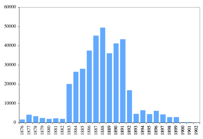
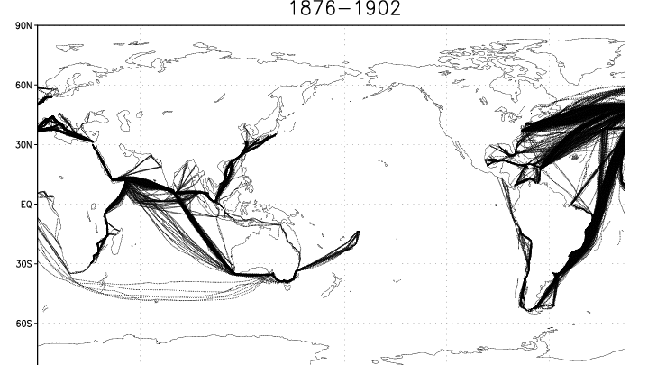
DWD Marine Meteorological Archive: Newly Digitized Data (deck 720; 1876-1902) (by ESRL)
Note: This DRAFT webpage contains fragmentary information, which the 2012 termination of ICOADS development provided insufficient time to finalize, but this directory contains available additional software/information.


- 37 - 37 1 type of position determination
undocumented 5, 6, 7, and 8
IMMA |Deutscher Wetterdienst Hamburg, 09.Nov.2007
|Marine Meteorological Archive
|
|
|====================================
|Description of HISTOR Working Format
|====================================
|
|General information:
|
|The data are not yet checked for meteorological errors.
|
|Temperature
|The readings of the thermometers (dry bulb, wet bulb, and sea surface)
|are corrected according to the instrument correction information.
|
|Air pressure
|The barometer readings are temperature corrected according to the auxiliary
|thermometer temperature.
|The reduction to sea level has generally been performed, with rare
|exceptions which can not be identified anymore.
|The gravity correction has not been made.
|
|Sea level pressure is given in this format without an index:
| - Values beginning with digit "7" in column 68 are to be read as
| tenths of mm, e.g. 7456 means 745.6 mm.
| - Values beginning with digit "2" in column 68 are to be read as
| hundredths of inch, e.g. 2986 means 29.86 inch.
|
|Date/time
|The date and time information is taken from the original logbook without change.
|
|Position
|During the time sequence position check the missing positions were calculated
|from the given positions (mostly 12 hour observation) and the course/speed
|informations from inbetween. Errors have been manually corrected.
|
|Meteorological Quality Control
|The quality control concerning meteorological errors has not yet been
|applied to the data.
|
|
|
|------------
|header line:
|------------
|
| columns length contents
| ======= ====== ========
|
| 1 - 4 4 book number
| 5 - 5 1 blank
| 6 - 9 4 start year (not always available)
| 10 - 14 5 blank
| 15 - 18 4 end year (not always available)
| 19 - 74 56 blank
| 75 - 77 3 header line identifier 999
|--- end of header line ---
|
|
|
|---------------------------------
|data line (line 2 to end of file)
|---------------------------------
|
| columns length contents
| ======= ====== ========
|
|Organisation
ID5-8 | 1 - 4 4 sequence number in file
| 4 - 5 1 blank
ID1-4 | 6 - 9 4 book number
| 10 - 10 1 blank
| 11 - 11 1 type of ship
| blank or 2: sailing ship
| 3: steam ship
|
|Date and time
DY | 12 - 13 2 day of month
MO | 14 - 15 2 month of year
YR | 16 - 18 3 year (first decimal place omitted)
HR | 19 - 20 2 hour of day(local time)
|
|Position
LAT | 21 - 22 2 latitude (degrees)
LAT | 23 - 24 2 latitude (minutes)
LAT | 25 - 25 1 latitude-index
| 0: north
| 1: south
LON | 26 - 28 3 longitude (degrees)
LON | 29 - 30 2 longitude (minutes)
LON | 31 - 31 1 longitude-index
| 0: east
| 1: west
|
|Magnetic variation
D,WD,SD| 32 - 33 2 magnetic variation (degrees)
| 34 - 34 1 magnetic variation(cardinal point)
| 35 - 35 1 magnetic variation(rhumb)
D,WD,SD| 36 - 36 1 magnetic variation index
| 0: east
| 1: west
|
|Position determination
| 37 - 37 1 type of position determination
| 0: astronomical
| 1: bearing
| 2: calculated
|
|Course information
| 38 - 38 1 course index
| 0: true heading
| 1: magnetic heading
|
|1st course
| 39 - 39 1 1st course index
| 0: north
| 1: south
| 40 - 41 2 1st course direction (degrees)
| 42 - 42 1 1st course index (cardinal point)
| 43 - 43 1 1st course index (rhumb)
| 44 - 44 1 1st course index
| 0: east
| 1: west
| 45 - 46 2 1st course distance (nm)
|
|
|2nd course
| 47 - 47 1 2nd course index
| 0: north
| 1: south
| 48 - 49 2 2nd course (degrees)
| 50 - 50 1 2nd course (cardinal point)
| 51 - 51 1 2nd course (rhumb)
| 52 - 52 1 2nd course index
| 0: east
| 1: west
| 53 - 54 2 2nd course distance (nm)
|
|
|3rd course
| 55 - 55 1 3rd course index
| 0: north
| 1: south
| 56 - 57 2 3rd course (degrees)
| 58 - 58 1 3rd course (cardinal point)
| 59 - 59 1 3rd course (rhumb)
| 60 - 60 1 3rd course index east
| 0: east
| 1: west
| 61 - 62 2 3rd course distance (nm)
|
|Wind
D | 63 - 63 1 wind index
| 0: true heading
| 1: magnetic heading
D | 64 - 65 2 wind direction (32 degree compass card)
W | 66 - 67 2 wind force (Beaufort scale)
|
|Sea level pressure
SLP | 68 - 71 4 sea level pressure (mm or inch)
|
|Auxiliary thermometer
| 72 - 72 1 auxiliary thermometer
| 0: °C
| 1: °F
| 2: °R
| 73 - 73 1 auxiliary thermometer sign
| blank: positive temperature
| 1: negative temperature
| 74 - 77 4 auxiliary thermometer value (tenths degree)
|
|Dry bulb temperature
AT | 78 - 78 1 dry bulb temperature index
| 0: °C
| 1: °F
| 2: °R
AT | 79 - 79 1 dry bulb temperature sign
| blank: positive temperature
| 1: negative temperature
AT | 80 - 83 4 dry bulb temperature value (tenths degree)
|
|Wet bulb temperature
WBT | 84 - 84 1 wet bulb temperature index
| 0: °C
| 1: °F
| 2: °R
WBT | 85 - 85 1 wet bulb temperature sign
| blank: positive temperature
| 1: negative temperature
WBT | 86 - 89 4 wet bulb temperature value (tenths degree)
|
|
|Total cloud cover
N | 90 - 91 2 total cloud cover (tenths)
|
|
|Wind wave
WD | 92 - 92 1 wind wave index
| 0: true heading
| 1: magnetic heading
WD | 93 - 94 2 wind wave direction (32 degree compass card)
| 95 - 95 1 wind wave force (Petersen scale)
| 0: flat
| 1: very smooth
| 2: smooth
| 3: little movement
| 4: moderate movement
| 5: rather rough
| 6: rough
| 7: heavy
| 8: very heavy
| 9: abnormal
|
|Sea surface temperature
SST | 96 - 96 1 sea surface temperature index
| 0: °C
| 1: °F
| 2: °R
SST | 97 - 97 1 sea surface temperature sign
| blank: positive temperature
| 1: negative temperature
SST | 98 - 101 4 sea surface temperature value (tenths degree)
|
|
|Beaufort weather
|102 - 102 1 Beaufort weather since last observation
| 0: -
| 1: -
| 2: -
| 3: -
| 4: fog
| 5: drizzle
| 6: rain
| 7: snow
| 8: shower (drizzle, rain, snow or hail)
| 9: thunderstorm
|
|103 - 103 1 Beaufort-weather
| 0: b - blue sky
| 1: bc - sky less than ½ covered by clouds
| 2: c - cloudy, sky ½ covered by clouds
| 3: cc - sky ¾ covered by clouds
| 4: o - overcast
| 5: kb - no cloud reported
| 6: -
| 7: -
| 8: -
| 9: kw - no weather reported
|
|104 - 104 1 Beaufort-weather
| 0: f - foggy
| 1: f - thick fog
| 2: m - misty
| 3: m - thick mist
| 4: v - visibility clear
| 5: v - visibility very clear
| 6: z - hazy
| 7: g - gloomy
| 8: u - ugly
| 9: -
|
|105 - 105 1 Beaufort weather
| 0: d - drizzle (spray)
| 1: d - heavy drizzle
| 2: r - rain
| 3: r - heavy rain
| 4: p/pr - rain showers, rain squalls
| 5: p/pr - heavy rain showers / heavy rain squalls
| 6: -
| 7: qs/ps - snow showers / snow squalls
| 8: qs/ps - heavy snow showers / heavy snow squalls
| 9: pd/ds - drizzle shower
|
|106 - 106 1 Beaufort weather
| 0: s - snow
| 1: s - heavy snow
| 2: h - hail
| 3: h - heavy hail
| 4: sh - snow graupel
| 5: sh - heavy snow graupel
| 6: rs - rain and snow mixed
| 7: rs - heavy rain and snow mixed
| 8: -
| 9: -
|
|107 - 107 1 Beaufort weather
| 0: l - intermittend lightning
| 1: l - continuous lightning
| 2: t - intermittend thunder
| 3: t - continuous thunder
| 4: lt - thunderstorm
| 5: lt - intense thunderstorm
| 6: dr - drizzle with rain
| 7: dr - heavy drizzle with rain
| 8: rh - rain and hail
| 9: rh - heavy rain and hail
|
|108 - 109 2 Beaufort weather
| 0: q - squally
| 1: q - heavy squalls
| 2: ground fog
| 3: damp fog
| 4: wet fog
| 5: coastal fog
| 6: sun ring
| 7: sun halo
| 8: moon ring
| 9: moon halo
| 10: -
| 11: water spout / wind spout
|
|110 - 111 2 Beaufort weather
| 0: w - dew
| 1: w - heavy dew
| 2: duststorm
| 3: frost
| 4: hoar frost
| 5: glaze
| 6: ice, floating ice, ice pack
| 7: iceberg
| 8: aurora
| 9: air mirage
| 10: -
| 11: St.Elmo's fire
| 12: wind shear
|
|Swell wave
SD |112 - 112 1 swell wave index
| 0: true heading
| 1: magnetic heading
SD |113 - 114 2 swell wave direction (32 degree compass card)
|115 - 115 1 swell wave force (Petersen scale)
| 0: no swell
| 1: very low
| 2: low
| 3: slight
| 4: moderate
| 5: rather rough
| 6: rough
| 7: heavy
| 8: very heavy
| 9: abnormal
|
|Correction information
|116 - 134 19 columns to receive intermediate correction informations
| (this part should be ignored)
|
|
|--- end of data line ---
|--- end of description of HISTOR Working Format ---
|
[Documentation and Software][Translation information]
U.S. National Oceanic and Atmospheric Administration hosts the icoads website privacy disclaimer
Document maintained by icoads@noaa.gov
Updated: Apr 20, 2015 19:43:13 UTC
http://icoads.noaa.gov/dwd2.html