
| Data and Documentation | Chronology and News | Program Status | Publications | Related Data and Resources | Contact Points |
ICOADS Web information page (Wednesday, 11-May-2016 19:09:54 UTC):
Release 2.5 (Preliminary) Data Characteristics
1. Introduction
This webpage provides temporal and spatial comparisons between preliminary Release 2.5 and Release 2.4 data for 1662-1969, links to additional webpages exploring in detail noteworthy homogeneity questions in the preliminary data, and plots illustrating duplicate elimination (dupelim) performance and quality control results (note: characteristics of final 1662-1969 Release 2.5 data are described on this webpage).
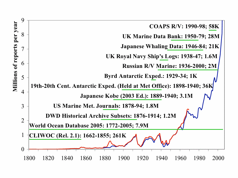
Figure 1.
The time periods of major new or improved data sources being blended into Release 2.5 are spanned by horizontal green lines. Each dataset name is appended with the date range and approximate number of reports. The solid blue curve is the number of Release 2.4 reports; the solid red curve is the number of preliminary Release 2.5 reports through 1969.
2. Release 2.5 (preliminary) 4-panel plots
Figures 2a1 through 2i6 provide 4-panel comparison plots between preliminary Release 2.5 data and Release 2.4 data (2° enhanced monthly summaries in both cases) for 20-year periods (for details on the 4-panel plot layout see icoads.noaa.gov/panels.html; note that a minimum of 1000 nobs are required per month, or all curves are omitted to ensure meaningful data patterns).
The humidity plots are omitted for the earliest three periods due to general data sparsity.
| 2° ENH | 1850-1869 | 1870-1889 | 1890-1909 | 1910-1929 | 1930-1949 | 1950-1969 |
|---|---|---|---|---|---|---|
| Sea Surface Temperature | Figure 2a1 | Figure 2a2 | Figure 2a3 | Figure 2a4 | Figure 2a5 | Figure 2a6 |
| Air Temperature | Figure 2b1 | Figure 2b2 | Figure 2b3 | Figure 2b4 | Figure 2b5 | Figure 2b6 |
| Scalar Wind | Figure 2c1 | Figure 2c2 | Figure 2c3 | Figure 2c4 | Figure 2c5 | Figure 2c6 |
| U Wind Component | Figure 2d1 | Figure 2d2 | Figure 2d3 | Figure 2d4 | Figure 2d5 | Figure 2d6 |
| V Wind Component | Figure 2e1 | Figure 2e2 | Figure 2e3 | Figure 2e4 | Figure 2e5 | Figure 2e6 |
| Sea Level Pressure | Figure 2f1 | Figure 2f2 | Figure 2f3 | Figure 2f4 | Figure 2f5 | Figure 2f6 |
| Total Cloudiness | Figure 2g1 | Figure 2g2 | Figure 2g3 | Figure 2g4 | Figure 2g5 | Figure 2g6 |
| Specific Humidity | Figure 2h4 | Figure 2h5 | Figure 2h6 | |||
| Relative Humidity | Figure 2i4 | Figure 2i5 | Figure 2i6 |
3. Release 2.5 (preliminary) map comparisons
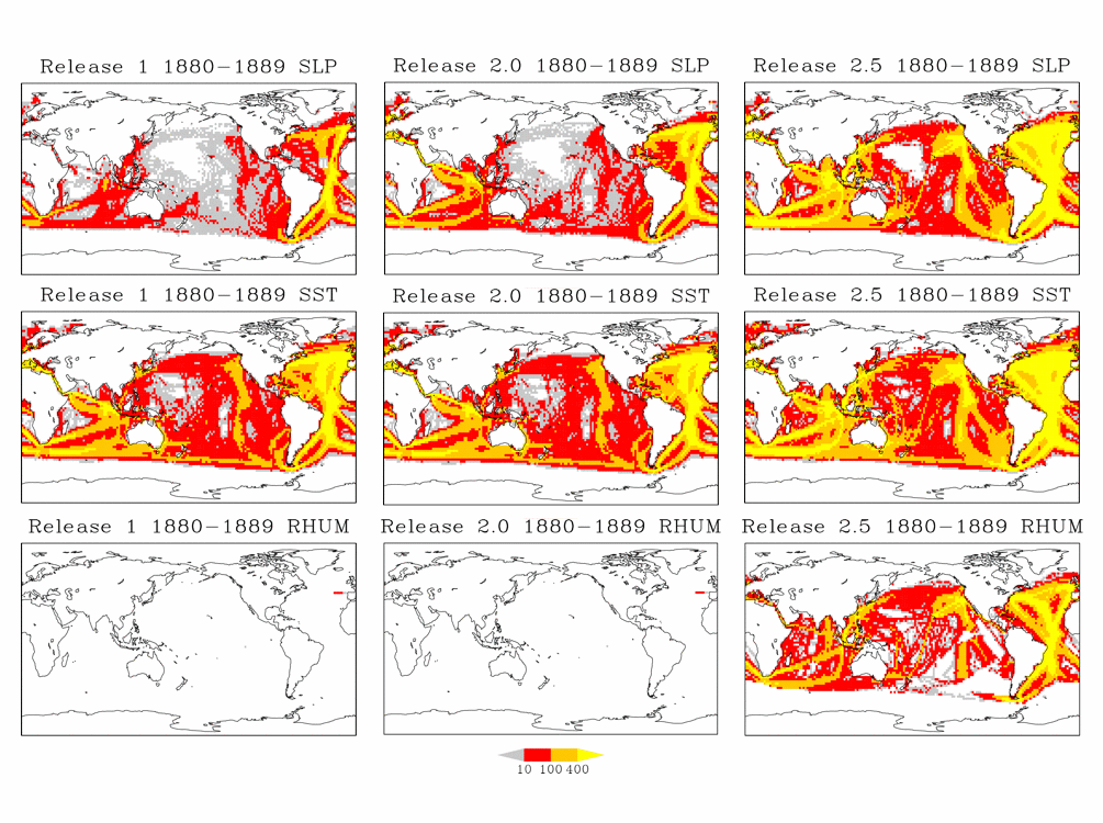
Figure 3. Decadal (1880-89) totals of sea level pressure (SLP) observations (upper) illustrating data additions between Releases 1, 2.0, and preliminary 2.5 data. The colors show the number of observations in a 2° box per decade. Grey indicates 1-10; red indicates 11-100; orange indicates 101-400; yellow indicates 401 or more. (Middle and Lower) As for (upper) except for sea surface temperature (SST) and relative humidity (RHUM). Note: More map comparison figures are planned for addition at a later date, to document coverage changes in final Release 2.5 data.
Figures 3e1 through 3g3 show decadal differences (preliminary Release 2.5 minus Release 2.4) of numbers of reports. The matrix of plots is organized by columns for each century, versus rows for each decade within the centuries. No data were added to Release 2.5 for the 1700s through 1730s, and the amounts of data added back to 1662 were very small, so plots for those decades have been omitted (note: Release 2.4 data began in 1784).
| 1700s | 1800s | 1900s | |
|---|---|---|---|
| 00s | Figure 3a2 | Figure 3a3 | |
| 10s | Figure 3b2 | Figure 3b3 | |
| 20s | Figure 3c2 | Figure 3c3 | |
| 30s | Figure 3d2 | Figure 3d3 | |
| 40s | Figure 3e1 | Figure 3e2 | Figure 3e3 |
| 50s | Figure 3f1 | Figure 3f2 | Figure 3f3 |
| 60s | Figure 3g1 | Figure 3g2 | Figure 3g3 |
| 70s | Figure 3h1 | Figure 3h2 | |
| 80s | Figure 3i1 | Figure 3i2 | |
| 90s | Figure 3j1 | Figure 3j2 |
4. Release 2.5 (preliminary) data continuity questions
The following three webpages explore some noteworthy data-difference patterns (between preliminary Release 2.5 data and Release 2.4 data) for three variables:
Sea surface temperature (SST)5. Release 2.5 (preliminary) dupelim results
Sea level pressure (SLP)
Wind speed (W)
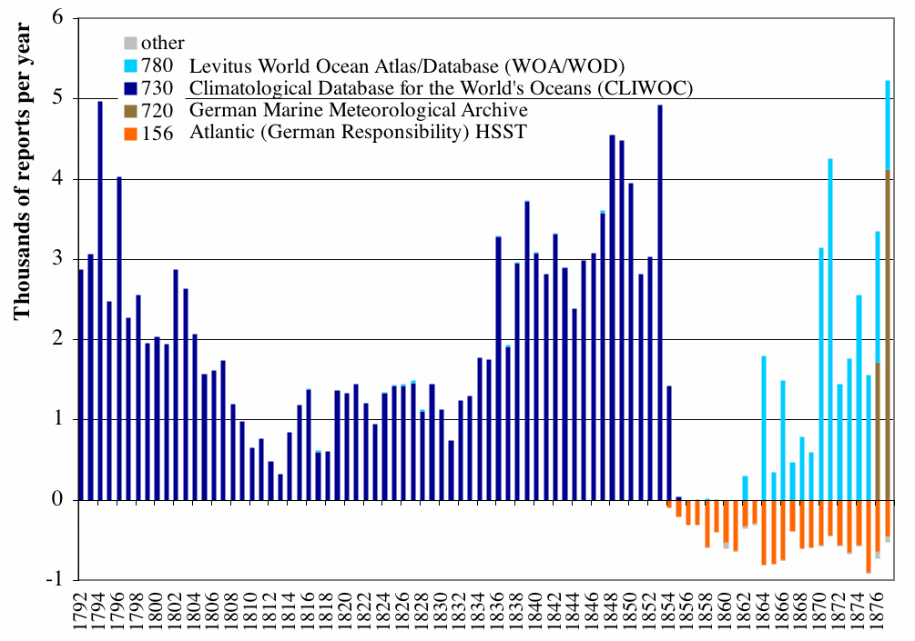
Figure 4a. Numbers of reports added to, or deleted from, the output preliminary Release 2.5 data during dupelim, separately by deck, covering 1792-1877. The deck 156 reports deleted around 1860, without corresponding additions from other decks, were previously undetected duplicates (i.e., they matched other reports already in ICOADS).
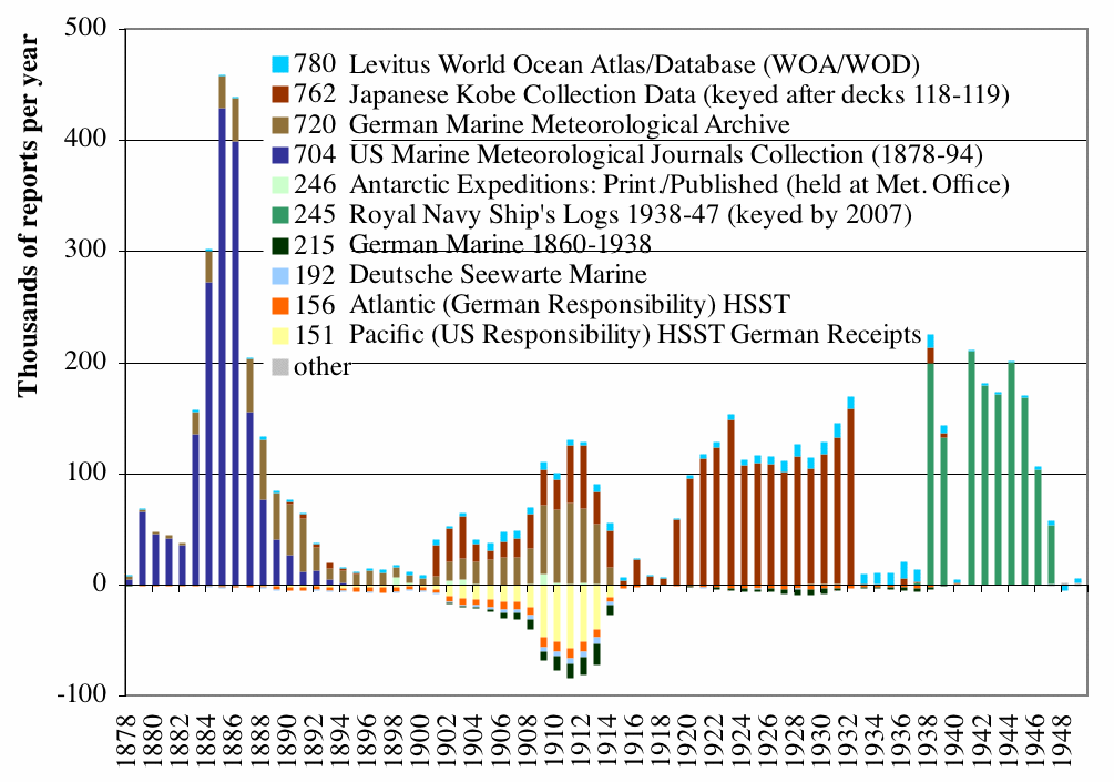
Figure 4b. As for Figure 4a, but covering 1878-1949.
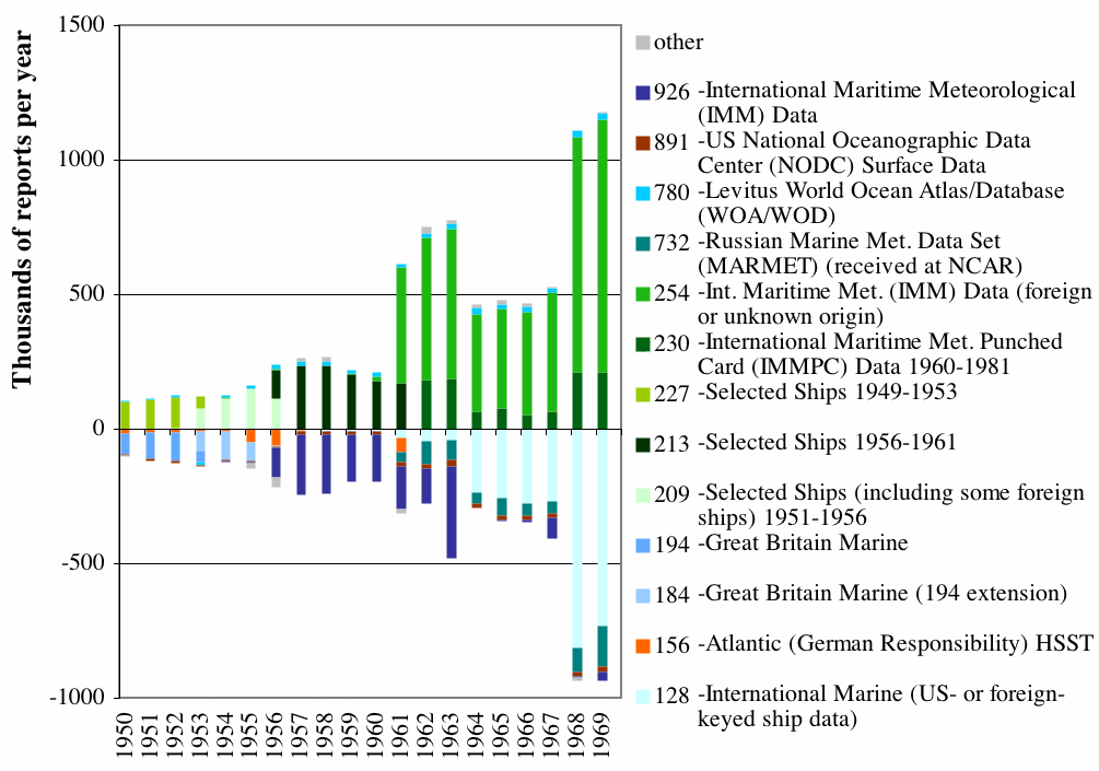
Figure 4c. As for Figure 4a, but covering 1950-69.
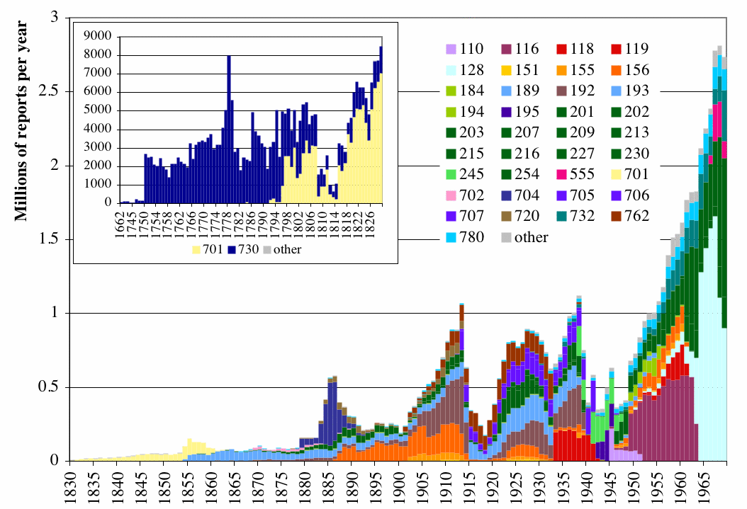
Figure 5. The larger plot shows total numbers of reports output in the preliminary Release 2.5 data, stratified by deck, for 1830-1969 (Tables D6a-D6c). The smaller plot shows patterns for the period prior to 1830, which is almost exclusively composed of data from decks 730 (CLIWOC) and 701 (US Maury).
6. Release 2.5 (preliminary) quality control results
In Figures 7a through 7f, bars show the percentage frequency (left axis) of observation (a1) trimming flag value. Specifically, where a1 is the individual observation under scrutiny, g is the smoothed median, and s1 and s5 are the smoothed lower and upper median deviation:
| E = data unusable (SF, AF, and PF, only) |
| C = limits missing (ocean/coastal box) |
| 7 = greater than 4.5 sigma upper limit (a1 > g + 4.5*s5) |
| 6 = less than 4.5 sigma lower limit (a1 < g - 4.5*s1) |
| 5 = greater than 3.5 sigma upper limit (g + 3.5*s5 < a1 <= g + 4.5*s5) |
| 4 = less than 3.5 sigma lower limit (g - 4.5*s1 <= a1 < g - 3.5*s1) |
| 3 = greater than 2.8 sigma upper limit (g + 2.8*s5 < a1 <= g + 3.5*s5) |
| 2 = less than 2.8 sigma lower limit (g - 3.5*s1 <= a1 < g - 2.8*s1) |
| 1 = within 2.8 sigma limits (g - 2.8*s1 <= a1 <= g + 2.8*s5) |
| sea surf. temp. (SF) | air temp. (AF) | u comp. wind (UF) | v comp. wind (VF) | sea level press. (PF) | rel. hum. (RF) |
|---|---|---|---|---|---|
| Figure 7a | Figure 7b | Figure 7c | Figure 7d | Figure 7e | Figure 7f |
[Documentation and Software][Links to additional]
U.S. National Oceanic and Atmospheric Administration hosts the icoads website privacy disclaimer
Document maintained by icoads@noaa.gov
Updated: May 11, 2016 19:09:54 UTC
http://icoads.noaa.gov/pre2.5.html