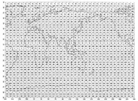
Figure G1-1. 10° boxes (larger numerals) over Marsden Squares (smaller
numerals).
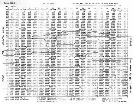
Table G2-1
BOX2

0. Introduction
The 10° and 2° box systems used in most of these data are defined and then illustrated on maps. The Marsden Square system and the approximate 2° landlocked file are also described. Refer to supp. H for a description of software tools available for use with 10° and 2° boxes, plus details on a machine-readable copy of the landlocked file and a program to read it.
1. 10° Boxes and Marsden Squares
The 10° box (BOX10) numbering system starts with the lower-left (SW) corner of BOX10-1 at 80°N, 30°E and proceeds east, spiraling down through each zone of latitude as follows (see also Figure G1-1):
       BOX10                1     2   ...    36    37   ...   648
SW corner lat ° (+N,-S)    80    80   ...    80    70   ...   -90
  SW corner lon ° (+E)     30    40   ...    20    30   ...    20
The 30° division was chosen to avoid splitting any ocean; therefore, the BOX10s in a 10° latitude zone across any ocean are sequential. (The transformation k = 36 * (j - 1) + i can be used to convert the indices (i, j) of a matrix spanning longitude and latitude, e.g., the FORTRAN array dimensioned BOX10 (36, 18), into a 10° box number k ranging from 1 through 648 as described above.)
Conventions a) and b) are the same as for Marsden Squares.
a) The convention for inclusion of data that fall on the boundary of a BOX10 is dependent on the quadrant: the two inclusive boundaries are those that form the corner nearest the intersection of the equator and the prime meridian (0°N/0°E).b) However, when the observation falls along the equator or the great circle through the prime meridian (0°E or 180°E), the choice is made by the observer.
Conventions a') and b') are necessary to complete the system.
a') Data at 90°N or 90°S exactly are assigned by convention to BOX10-1 or -648, respectively, and 1° Marsden Square 99 in both cases.The 10° Marsden Square (MSQ) numbering system is described here for reference (see also Figure G1-1). The system starts with the lower-right (SE) corner of square 1 at the equator and proceeds west from 0° longitude, spiraling up through each zone of latitude to 288 at 70°N, 10°E. Then following a gap in numbering from 289 through 299, it begins again just below the equator with square 300, and proceeds west from 0° longitude down through each zone of latitude to 623 at 90°S, 10°E. Finally, following yet another gap from 624 through 900, it begins again with squares 901 through 936 numbered westward from 0° longitude at 80°N latitude.b') In the event the observer's choice is not available, the BOX10 chosen (whether the choice is between two or four BOX10s) is that with the highest number.
Each 10° Marsden Square can be further subdivided into 100 1° sub-squares, numbered 00 through 99 (1° box is synonymous with this 1° sub-square). After the global latitude and longitude are normalized such that -90° ≤ Yy ≤ 90°N and -180° ≤ XXx ≤ 180°E, the sub-square number is yx, i.e., concatenation of the units position of latitude and longitude. Exceptions are at 180°E, where yx must be set to y9, and 90°N or 90°S, where both the 10° and 1° Marsden Square are undefined.
2. 2° Boxes and Landlocked File
The 2° box (BOX2) numbering system starts with BOX2-1 at the North Pole and proceeds east from the prime meridian down through each zone of latitude to 16202 as given by the following:
BOX2-1 is reserved for data at 90°N exactly; thereafter,
        BOX2                2     3   ...   181   182   ... 16201
SW corner lat ° (+N,-S)    88    88   ...    88    86   ...   -90
  SW corner lon ° (+E)      0     2   ...   358     0   ...   358
BOX2-16202 is reserved for data at 90°S exactly.
(The transformation k = 180 * (j - 1) + i + 1 can be used to convert the indices (i,j) of a matrix spanning longitude and latitude, e.g., the FORTRAN array dimensioned BOX2(180, 90), into a 2° box number k ranging from 2 through 16,201 as described above, exclusive of the two polar boxes.)
The convention for inclusion of data that fall on the boundary of a BOX2 is the same as that for a 10° box. Whether the choice of BOX10 for a report was made by the observer or assigned under convention b'), as discussed in sec. 1, it was given the number of the BOX2 enclosed by that BOX10.
Table G2-1 gives in 18 pages the latitude and longitude at the lower-left (SW) corner of each BOX2. The first nine of these (computer generated) pages cover the Northern Hemisphere working eastward from 0°E, and the last nine pages cover the Southern Hemisphere working eastward from 0°E. Each group of 25 (or in the two polar cases 26) BOX2s is delimited as a BOX10, and the BOX10 and MSQ numbers are given at its top. In addition, approximate land boundaries are marked with hand-drawn lines. The names of major land masses have also been marked.
These land boundaries were drawn using values derived from a modified version of the NCDC landlocked file, called LLN2F1, which is available in machine-readable form (see supp. H). The space following each BOX2 shows the specific value associated with it: a period <.> for land, an asterisk <*> for coastal (i.e., any mixture of land and sea), or a space < > for sea. In general, rivers and lakes are shown as land; thus all land <.> boxes form the group referred to as "landlocked" that was automatically trimmed.

Figure G1-1. 10° boxes (larger numerals) over Marsden Squares (smaller
numerals).
Table G2-1
BOX2
